Campsites and Special Places
Along the Jefferson River Canoe Trail
By Thomas J. Elpel
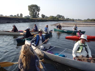
The Jefferson River Canoe Trail retraces by water an essential segment of the Lewis & Clark National Historic Trail from the Three Forks of the Missouri at Headwaters State Park upstream along the Jefferson River to its origin at the confluence of the Big Hole and Beaverhead Rivers near Twin Bridges. The Jefferson River Chapter LCTF has created detailed conservation and recreation maps of the Jefferson River Canoe Trail showing all state, BLM and Forest Service lands along the river corridor, as well as conservation easements, formal and informal fishing access sites and hiking trailheads, plus the approximate locations of actual Lewis and Clark campsites.
Most present-day travelers will prefer to follow the trail in reverse, paddling down the Jefferson River, instead of towing their canoes or kayaks upstream. The Jefferson River Canoe Trail begins on the Beaverhead River at Jessen Park in Twin Bridges. Twin Bridges offers a grocery store, gas, restaurants, motel rooms and cabins, fishing tackle and outfitters, and a new Sacagawea park at the fairgrounds. Optionally, paddlers can start at numerous other points along the Jefferson River. Be sure to bring a trash bag to collect any debris you find along the river!
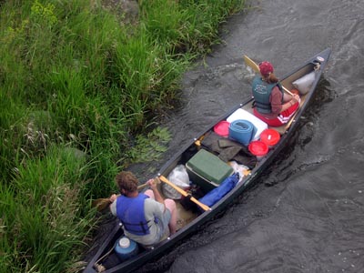
 Paddlers can choose a fast pace, completing the trail in three to four days, or a slower pace, paddling half days to more thoroughly experience backcountry campsites and riverside activities along the way.
The Jefferson River Canoe Trail presently includes nine designated camping areas, including four sites on BLM land, two on state lands, and three on properties acquired for the public by the Jefferson River Chapter. Camping is also allowed within the ordinary high water mark, as allowed for by Montana's Stream Access Law. Please note that this is a no trace canoe trail. Use our map to locate a suitable campsite where public use is allowed, then apply appropriate backcountry etiquette to leave the area as nice as you found it.
The Jefferson River is entirely Class I water, suitable for beginning paddlers, except during runoff season in the spring, through much of May and June. Low water in mid to late summer, especially August, may require extensive dragging of watercraft over shallow riffles and necessitate more days to complete the river.
Launching from Jessen Park in Twin Bridges, follow the Beaverhead River downstream for two miles to its confluence with the Big Hole, forming the Jefferson River. There is a wooden diversion dam on the Beaverhead River, which can usually be floated on the left side.
 Lewis and Clark spent three days around the confluence of the Big Hole and Beaverhead Rivers as they searched for Sacagawea's people and tried to determine the best river route westward. On August 4th, 1805, Lewis scouted the area in advance with a small party of men on foot and left a note on a tree advising Clark not to take the Big Hole River route. But a beaver cut down the tree before Clark and his party arrived there on August 5th. They traveled a very difficult mile up the Big Hole and camped overnight before turning back on August 6th. They tipped a canoe on the way down, soaking some of their powder and losing some gear.
Joseph Whitehouse was thrown from a canoe in the rapids losing his shot pouch and horn. Lewis wrote, "the canoe had rubed him and pressed him to the bottom as she passed over him and had the water been 2 inches shallower must inevitably have crushed him to death. Our parched meal, corn, Indian preasents, and a great part of our most valuable stores were wet and much damaged on this ocasion."
The entire expedition camped together on a gravel bar at the confluence where there was an abundance of firewood. Lewis wrote, "here we fixed our camp, and unloaded all our canoes and opened and exposed to dry such articles as had been wet. A part of the load of each canoe consisted of the leaden canestirs of powder which were not in the least injured, tho' some of them had remained upwards of an hour under water."
Continuing downstream, watch for hazardous submerged cottonwood trees in the river. Stay in the main channel, and avoid the irrigation diversion on the right side near Hells Canyon.
Hells Canyon FAS (Fishing Access Site) (mile 77.5) is just a little farther down on the left side, tucked behind a small island. Watch out for the diversion dam on the downstream end of this island. Paddlers should plan to paddle upstream from the launch to get back to the main river channel.
William Clark camped near the present-day Silver Star FAS (mile 72.5) on August 4th, 1805. Clark recorded that gooseberries and currents were abundant on that day. Available services in Silver Star include a post office and general store with ice cream, snacks, and nature books. There is a vault toilet at the fishing access site.
Heading downstream from the Silver Star, one may experience floating back in time. The river winds away from the highway and most of the noise, so that in many places you will see only wildlands and wildlife in the foreground, with the untamed Highlands and Tobacco Root Mountains in the background. Most houses and developed areas are invisible from the viewpoint on the river.
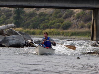 There are not yet any designated camping areas along this portion of the Jefferson, but camping is allowed within the ordinary high water mark, as allowed by Montana Stream Access Law. This stretch of the river is a significant gap in the Canoe Trail, and we hope to acquire suitable land for public campsites in this area.
Watch out for the diversion dam at Parson's Bridge, a.k.a. Waterloo, (mile 63). This large pile of boulders across the river could cause a bad accident. Stop and survey the situation before reaching the dam, or better yet, drive to it before your float.
It is sometimes possible for skilled paddlers to float over the diversion, which was reconstructed in 2014 with an improved pass-through chute in the middle of the dam. Otherwise, it may be necessary to hug the right bank and tow your boat down over the rocks or better yet, portage on the left side, where you will carry gear and canoes through a narrow walkway to get over the irrigation ditch. That takes you right into Lost Tomahawk campsite:
Jefferson River Canoe Trail Campsites

Lost Tomahawk (River Mile 63)
Thanks to all who helped make our acquisition of Lost Tomahawk a success. We raised $270,000 in grants and donations in 2017 to purchase this beautiful 30-acre parcel as a walk-in fishing access site and public paddlers' camp.
 The property was originally named Waterloo Grove for fundraising purposes. Later, we met with the seventh grade Montana History class from Whitehall School to choose a Lewis and Clark name for the property. Students read the local journals of Lewis and Clark, suggested names, and voted in favor of "Lost Tomahawk."
On August 2, 1805, Lewis and a small party of men were exploring ahead of the main expedition when they camped on the opposite side of the river from our newly acquired campsite. Lewis recorded in his journal, "Soon after passing the river this morning Sergt. Gass lost my tommahawk in the thick brush and we were unable to find it, I regret the loss of this usefull implement, however accedents will happen in the best families, and I consoled myself with the recollection that it was not the only one we had with us." The story of naming the campsite was reported in the Whitehall Ledger.
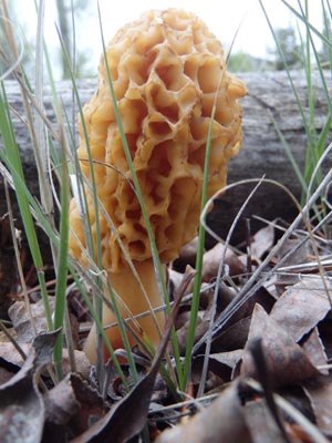
Lost Tomahawk serves as a convenient walk-in fishing access site and picnic area serving the Jefferson Valley. The property features a diverse mix of cottonwood, juniper, water birch, willow, and rich forage, plus lots of whitetail deer. At 30.53 acres, it will be the only substantial piece of riparian public land on the upper Jefferson where people can walk their dog, go bird watching, or hunt for morel mushrooms. Read more about Lost Tomahawk.

Point of Rocks (River Mile 57)
Downstream you will soon pass under a railroad bridge, then gradually float back into undeveloped spaces rich with wildlife. Throughout the day you can see the landmark called Point of Rocks at the northern end of the Tobacco Roots Mountains and mark your progress towards it.
Point of Rocks is an informal campsite on BLM land and a good place to hike up into the hills. A high cave includes one nice remaining Native American pictograph. Other pictographs have been destroyed by vandals over time. Stop and imagine going back in time to vision quest at this site with a grand view of the Jefferson Valley. Also be sure to enjoy a soak in Renova Hot Springs, but avoid coming on the weekends when the site can turn into a party zone. Please help to pick up trash around the campsites and hot springs.
Continuing downriver from Point of Rocks, you will soon find the massive stone walls of Parrot Castle on the right bank, the remains of an early smelter used to process ore from local mines. Follow the left channel when the river splits around the island. On the left bank is Parrot Castle Fishing Access Site (mile 55), with the Parrot Castle Diversion Dam across the middle of the river. The diversion dam is sometimes floatable, or you can portage it on the left bank, although the portage can be challenging through the rocks and bushes. There is a vault toilet at Kountz Bridge Fishing Access Site (mile 49) if you need to make a pit stop along the way.
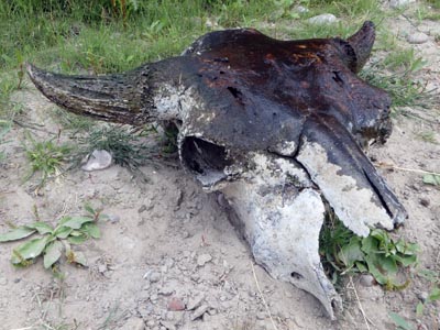 Below Kountz Bridge, the river braids into channels wrapping around several large islands rich with wildlife. In late summer, only the right channel is deep enough to paddle through. In many places the only visible sign of modern civilization is the reclamation contouring of the Golden Sunlight mine to the north.
On August 2nd, 1805 Captain Lewis noted the snowcapped peaks of the Highlands and Tobacco Root Mountains and recorded, "The tops of these mountains were yet partially covered with snow while we in the valley were suffocated nearly with the intense heat of the midday sun. The nights are so cold that two blankets are not more than sufficient covering."
The islands are currently private, but we hope to negotiate a permanent interest in one of these islands, or an easement on it, from a willing seller for a unique backcountry campsite. Paddlers will be able to stop to enjoy the remote setting, hunt for mushrooms, and enjoy the birds and wildlife.
Back on the river, you will soon pass Mayflower Bridge FAS (river mile 44), and a few miles later Cardwell FAS (mile 39). There is a vault toilet at the Cardwell site for a convenient pit stop. If you are ready for a break from camp fare, then stop for a great restaurant meal at La Hood (mile 36.5). Otherwise, continue floating on down into the canyon for a night's stay at Canyon Corner.
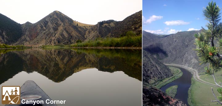
Canyon Corner (River Mile 34)
The Jefferson River Canyon is vastly different from the upper and lower stretches of the river. Confined by the rugged canyon, the river is unable to meander back and forth to create the new channels required to stimulate germination of cottonwood seedlings. Thus, there are few cottonwood trees and very little riparian zone beyond the willows hugging the riverbanks. A few feet beyond the river, the landscape is more desert-like, with a wholly different mix of plants, flowers, shrubs, and trees.
Geology becomes a prominent aspect of the landscape within the canyon, especially the uplifted limestone strata of the London Hills near the head of the canyon. Canyon Corner is a designated Canoe Trail campsite with BLM land along both sides of the river. William Clark shot a bighorn sheep at Canyon Corner near the red rocks in the cliffs. Those hills are public land, offering access to more than a thousand acres of BLM and state land on the east end of the London Hills. Hike up to the highest point for a great view back up the Jefferson Valley.
Canyon Corner is near the road, but remarkably quiet. Unfortunately, a new house was built on private land overlooking the site in 2014, although it is still a good distance away. There is public access to thousands of acres of great backcountry hiking at Lewis and Clark Caverns State Park just west of the new house. The explorers did not know the caverns were there when they passed through, but Lewis noted the "tremendous clifts of ragged and nearly perpendicular rocks" on August 1st, 1805.

Swift Current (River Mile 31)
Just moments downstream from Canyon Corner you cannot miss the manmade, but very alluring cave at the Sheep Gulch gypsum quarry. People have explored and partied at this site for decades. Fish, Wildlife, and Parks wanted an easement across the land for public hiking access up Sheep Gulch, but the landowner fenced and marked the property with "No Trespassing" signs in 2015.
Access to the main entrance of Lewis & Clark Caverns State Park is somewhat inconvenient from the river, but you can stop at Limespur Fishing Access Site (mile 31.5) and walk to the park entrance from there. Be sure to visit the caverns while in the area, and allow plenty of time to hike the three miles up to the caverns if you don't have wheels. The Caverns Campground is a nice place to camp, but too far from the river to be of practical use to paddlers.
For overnight camping, try Swift Current on BLM land immediately downstream from Limespur Fishing Access Site. On August 1, 1805 private Joseph Whitehouse recorded that "we proceeded on. find currents as usal and choak cherrys along the River. the current Swift the hills higher and more pine and ceeder timber on them. we passed high clifts about 500 feet high in many places."
Swift Current is the ideal campsite for anyone wanting to take a full day to visit the Caverns. However, be cautious of and do not meddle with the adjacent active mining claim. There is plenty of room for camping away from the mine. The claimholder often mows the grass in patches near the river suitable for tent sites.
On the south bank of the river lies the old bed of the Chicago Milwaukee Railroad and the foundation remains of the town of New London, all private land. We would like to negotiate rights to this railroad bed for use as a recreational trail. We would also like to see a conservation easement on the north face of the London Hills to protect the viewshed as seen from the Caverns.
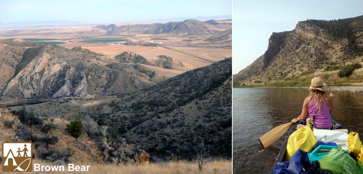
Brown Bear (River Mile 28)
Downstream from the Caverns, the river bends around the mountain and emerges from the scenic canyon landscape. Brown Bear is a Canoe Trail campsite on 290 acres of BLM land offering great hiking access to the east end of the London Hills. Most of the river bank is fairly steep here. Bring a long rope to tie your canoe off to the sumac bushes above. Carry your gear up over the old railroad bed to camp. Note that there isn't much shade available on this site, and it is helpful to bring your own firewood.
A little farther downstream, Antelope Creek enters from the right side. Lewis and Clark camped here on July 31st, 1805. Upon seeing the terrain ahead of him (upstream), Lewis wrote "The mountains on both sides of the river at no great distance are very lofty. We have a lame crew just now." Lewis and Clark reported chasing a brown bear or grizzly into the bushes not far from Antelope Creek. They surrounded the bushes but were unable to find it.
At Antelope Creek today you will hear the endless buzz of the nearby Magris Talc plant, which is largely out of earshot from the campsite at Brown Bear.
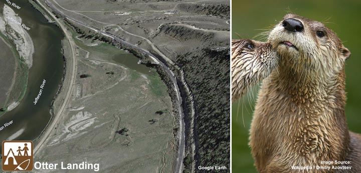
Otter Landing (River Mile 26)
The newest campsite on the Jefferson River Canoe Trail is Otter Landing, located just two miles downstream from Brown Bear on river right. In 2025, members of the Jefferson River Chapter of the Lewis and Clark Trail Alliance raised $40,000 and purchased the 4.43-acre site. The parcel is part of the abandoned right of way of the old Chicago, Milwaukee, St. Paul, Pacific Railroad, which went bankrupt and dissolved in the 1980s.
Note that the banks are somewhat steep and the parcel is well within earshot of the Magris Talc plant a half-mile downstream. Otter Landing is surrounded by 8 additional acres of state land in an old channel of the river that wraps around the parcel. A pond provides great waterfowl habitat for bird-watching, but can also be a source of mosquitoes.
There is also potential access to160 acres of state land on the north-facing slope immediately south of the BNSF spur line railroad track that leads to Harrison. Trains traverse the track only a few times per year. Otter Landing has not yet been included on our paper maps.
Meriwether Lewis reported seeing vast numbers of beaver and otter as the Corps of Discovery ascended the Jefferson River from Willow Creek to Antelope Creek on July 31, 1805. Otters are members of the Weasel family. They seldom attack people, but may be territorial, especially while raising young. Please be cautious swimming or wading in the river here, especially when otters are likely to be active in the morning and evening.
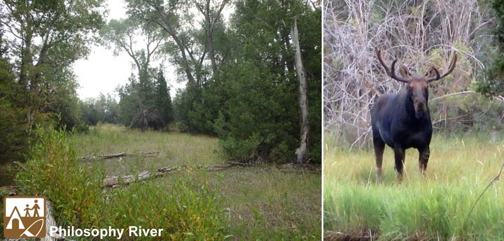
Philosophy (River Mile 17.5)
Two quick miles downriver from Otter Landing takes you past the talc plant to Sappington Bridge FAS (mile 24). There isn't a vault toilet at Sappington Bridge, but probably should be. This section, from Sappington Bridge to Williams Bridge, is the most heavily used portion of the Jefferson River. Big parties occassionally take to the river with tubes, sometimes parking a hundred vehicles or more at Sappington Bridge FAS and along the highway, but that only happens a few times a summer.
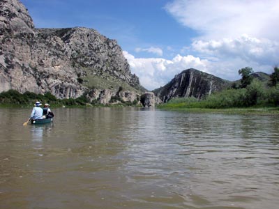 These few miles take you back into a small, but remarkably isolated and scenic hideaway with limestone cliffs where it seems as though the river opted for the path of greater resistance, cutting through the limestone hill, instead of flowing around it. This would be an ideal spot for a future campsite, but is presently in private hands.
An irrigation diversion dam at this spot used to consist of a small pile of round rocks in the river, easily floatable, but as the river channel has dug deeper, the dam has been built higher. This diversion dam is now nearly as big as the diversion dam at Parson's Bridge. There is a boat channel on the left side, but it isn't always floatable. It is best portaged on river right.
Paddlers used to climb a small cliff near the head of the irrigation ditch to jump into a deep pool, but due to liability concerns, the landowner obtained a permit (with inadequate public input), and dynamited the cliff.
Almost immediately after the cliffs area, the hills recede from the river, giving way to wide open bottomlands and numerous farms and ranches. Williams Bridge FAS (mile 19.5) has a vault toilet for a convenient pit stop along the way.
Paddlers can continue downriver beyond Williams Bridge to a nicely secluded 40-acre parcel of state land at the mouth of Willow Creek, which Lewis originally named as the "Philosophy River" on July 30th, 1805. The river runs through the middle of this parcel, and much of it consists of gravel bars. However, there are some nice campsites with cottonwoods and/or junipers around the perimeter of the property. Keep an eye on your map, as it is easy to miss the creek, the campsite, and the nearby town of Willow Creek as you drift downstream.
Drouillard Island (River Mile 9)
From Philosophy, it is a pleasant float downstream through cottonwoods and farmlands. The river eventually squeezes up against Highway 287 and scenic limestone bluffs for a few miles, then passes by riverside residences on the high ground. The last structure is mansion built only inches above the floodplain. In high water years, the house may be entirely surrounded by water.
Look for Droulliard Island (mile 9) just before the Highway 2 bridge, with Drouillard Fishing Access Site immediately after the bridge on river right.
These sites are named after George Drouillard, born of a Shawnee mother and French father in 1773 or 1775. Drouillard served as an interpreter and hunter on the Lewis and Clark Expedition, although Lewis misspelled his name as "Drewyer" throughout the journals.
Drouillard returned to the Missouri Headwaters after the Lewis and Clark Expedition with Manuel Lisa's Missouri Fur Company. He was killed, beheaded, and mutilated nearby in conflict with Blackfeet or Gros Ventre in 1810.
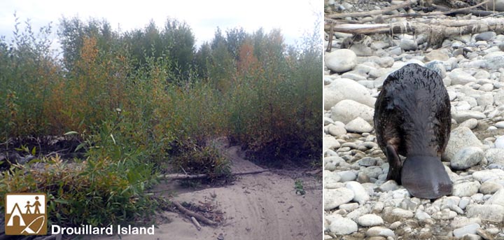
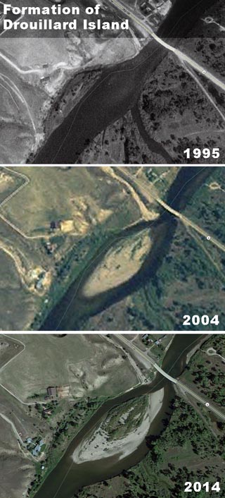
The five-acre Drouillard Island formed only recently through accretion from the riverbed, as shown in the accompanying Google Earth images. According to Montana law, the state owns the riverbed, and therefore owns any land that forms through accretion from the riverbed, even if the land should one day attach to one bank or the other. Drouillard Island presently falls within the ordinary high water mark, where the public can legally camp anyway. However, as trees and grass continue to colonize the island and the river channel digs in deeper around it, this new island will remain as public land, even if the river eventually shifts to one side or the other.
Drouillard FAS has a vault toilet for a convenient pit stop. This is also the westernmost end of the Three Forks trail systerm, featuring eight miles of paved trails from here all the way to Missouri Headwaters State Park. Check it out by foot or bicycle!

Shoshone Landing (River Mile 4)
Below DrouIllard, the Jefferson passes under I-90 and shortly thereafter, Old Town Bridge. On the right side, immediately before the bridge, is Shoshone Landing, the first campsite purchased by the Jefferson River Chapter for the public. Stop for a picnic, and stay overnight if you can. It is a lovely 4.3-acre property. We have fixed fences, installed access gates and barbecue grills, and we planted numerous cottonwood, juniper, dogwood, and chokecherry trees on the property. Please use the available five-gallon buckets to water trees near the river.
Downstream, the Jefferson merges with the Madison to form the Missouri River. The Gallatin flows into it shortly afterwards. Upon arrival at the Missouri Headwaters on July 27th,1805, Lewis "ascended the point of a high limestone clift from whence I commanded a most perfect view of the neighbouring country." It is now known and Lewis' Rock. The party camped at the Missouri Headwaters for three nights to rest and repair gear, before starting up the Jefferson River on their route to the Pacific. Read more about Shoshone Landing.
There is a developed campground a short distance up the Madison River at Headwaters State Park for present day travelers to rest and recreate, but it is not easily accessed from the river. Most weary river travelers will skip the camping and exit the river at Missouri Headwaters FAS just downstream from the confluence with the Gallatin River. For the more adventurous traveler, this is the starting point to trace Lewis and Clark's route up the Jefferson River, instead of down!

See also:
Jefferson River Canoe Trail Overview
Floating and Recreation on the Jefferson
Lewis & Clark on the Jefferson River
Return to the Jefferson River Canoe Trail Home Page
Jefferson River Chapter LCTHF
PO Box 697
Pony, MT 59747
Contact Us
Become a Member
Join us today!


 Jefferson River Chapter Membership: Join us Today!
 Paddlers can choose a fast pace, completing the trail in three to four days, or a slower pace, paddling half days to more thoroughly experience backcountry campsites and riverside activities along the way.
 Lewis and Clark spent three days around the confluence of the Big Hole and Beaverhead Rivers as they searched for Sacagawea's people and tried to determine the best river route westward. On August 4th, 1805, Lewis scouted the area in advance with a small party of men on foot and left a note on a tree advising Clark not to take the Big Hole River route. But a beaver cut down the tree before Clark and his party arrived there on August 5th. They traveled a very difficult mile up the Big Hole and camped overnight before turning back on August 6th. They tipped a canoe on the way down, soaking some of their powder and losing some gear.
 There are not yet any designated camping areas along this portion of the Jefferson, but camping is allowed within the ordinary high water mark, as allowed by
 The property was originally named Waterloo Grove for fundraising purposes. Later, we met with the seventh grade Montana History class from Whitehall School to choose a Lewis and Clark name for the property. Students read the local journals of Lewis and Clark, suggested names, and voted in favor of "Lost Tomahawk."
 Below Kountz Bridge, the river braids into channels wrapping around several large islands rich with wildlife. In late summer, only the right channel is deep enough to paddle through. In many places the only visible sign of modern civilization is the reclamation contouring of the Golden Sunlight mine to the north.


 These few miles take you back into a small, but remarkably isolated and scenic hideaway with limestone cliffs where it seems as though the river opted for the path of greater resistance, cutting through the limestone hill, instead of flowing around it. This would be an ideal spot for a future campsite, but is presently in private hands.


